Location: Rangitata
Rafts Hostel
Date: 5 june
2012
Time: 8:00
PM
The 4WD
tour—well, actually 8WD—was pretty cool.
First we went in an SUV (an old Land Cruiser, which was cool) for about ten
minutes to where the road ended by the bottom of the glacier, between two huge
sets of mountains. Interestingly,
it’s actually really close as the crow flies from here to the west coast, but
driving would take over ten hours because the mountains are impassible by
car. Then we (four of us and the
guide) got into an “argo,” an 8-wheel off-road vehicle, kind of like a mini
tank with wheels instead of a track.
It steers just by varying the speed of the wheels rather than actually turning
anything, which makes it a bit of a rough ride, but that just adds to the
experience. The argo was surprisingly
nimble.
 |
| The argo. |
The drive to the glacier was probably about a half hour each way along a twisty gravel track. On one side was the glacier wall, basically a huge mound of boulders and rocks that have been deposited there by the ice, and the other side is mountains with hugely active slide zones. The guide told us that if the rocks are darker, it means they slid recently (and that can be really dangerous, like an avalanche but deadlier), and if they’re lighter they are typically more stable.
Argo ride.
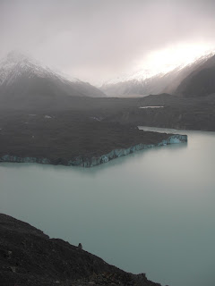
Once we got to the end of the track we hiked up the glacier wall to look at the ice. It was incredible. It’s hard to get a sense of how big it actually is because the mountains dwarf it, but it’s 2 km wide and sticks up 100-200 meters about the turquoise lake at its end. There are icebergs floating in the lake, remnants of pieces that fall off the glacier periodically. The ice is covered with a layer of gravel, which is essentially nature’s way of keeping the ice cold, so you see a mixture of blue ice and dark grey stone.
The glacier advances (i.e. goes downhill) about 5 meters per year, but it melts (i.e. retreats uphill) about 100 meters in that same time, so the net effect is that the glacier is retreating significantly, leaving a larger lake as it goes. Our guide is the first (and I think only) person to ever water ski on that freezing cold lake, which is obviously a crazy feat.
 |
| The path to the glacier. |
 |
| It's really hard to gauge the scale of that behemoth. |
 |
| Proof. I'm here. |
The weather wasn’t great this morning (surprise), but it was a worthwhile excursion nonetheless.
We rejoined the Stray Bus after our argo tour and headed on the last leg of our journey, to Rangitata via Lake Tekapo. Lake Tekapo is, I believe, a manmade lake. They say if the dam breaches, the surrounding towns have only a few seconds of warming before they are wiped out. They estimate the whole thing would empty in twelve minutes. Something tells me that’s just not the greatest idea…
We rejoined the Stray Bus after our argo tour and headed on the last leg of our journey, to Rangitata via Lake Tekapo. Lake Tekapo is, I believe, a manmade lake. They say if the dam breaches, the surrounding towns have only a few seconds of warming before they are wiped out. They estimate the whole thing would empty in twelve minutes. Something tells me that’s just not the greatest idea…
 |
| Actually, I don't think that's Lake Tekapo, but it looks just like that. |
 |
| Church of the Good Shepherd. A lot of people have weddings here, and I can see why. |
 |
| The good shepherd ('s shepherd) |
Our hostel tonight, Rangitata Rafts, is pretty unique. It’s a bit rustic (although not as rustic as Gunn’s Camp) and countryside-y. I guess it’s meant to be a sort of white water rafting outpost, and there are all sorts of pictures of crazy rapids on the walls.
 |
| We signed our names on the paddle at Rangitata Rafts |
 |
| The last dinner with my New Zealand family. |


No comments:
Post a Comment